skip to main |
skip to sidebar
Now, the cleanup of what was known as the American University Experiment Station is nearing a crucial point. This spring, the Army Corps of Engineers plans to tear down a house that may be atop a lost burial pit that an Army sergeant called “Hades” in a grainy 1918 photograph. That photograph ... has provided the surest clue to the pit’s location, which has been one of the most elusive mysteries in the nearly 20-year cleanup ...
More than 1,600 properties have been tested for arsenic, and the Army has removed tons of tainted soil, destroyed more than 1,000 munitions and carted off intact bottles of chemicals ... “What’s the risk to any of us in this community?” asked Dr. Lee H. Monsein, a radiologist who sits on the project advisory board. “Very, very low. What’s the cost to remove that risk, or mitigate that risk? Very, very expensive. Is it worth the money? Absolutely not."
 The exact location of the Maurer pit, as it is known, has remained a question. The corps believes, based on the photograph and other evidence, that a home next to the ambassador’s was built atop the pit, which may have been disturbed or even removed during construction ... Still, doubters remain. Kent Slowinski, a landscaper who grew up in the neighborhood and remains one of the corps’ most outspoken critics, believes the pit is higher on the hillside. “We keep finding out one thing after another where the Army corps says one thing and it turns out not to be true, and the situation turns out to be much worse than what they told us,” he said.
Theo Emery
New York Times
March 18, 2012 (pg. A-17)
 On the university campus, investigations will continue next month during students’ spring break, according to [project manager Dan] Noble. Cleanup crews will be looking at four spots on the Kreeger Hall roadway and parking lot ... The university-owned property at 4825 Glenbrook Road remains a topic of scrutiny. Noble said the Army Corps remains confident the property was a major burial pit for jars of mustard agent and other war debris, based on a 1918 photograph of a Sgt. Maurer along with aerial photographs from the same year. But Allen Hengst, a longtime critic of the cleanup effort who works at the university, said his own studies show that the “Sgt. Maurer Pit” is more likely across from the university’s Watkins Building.
Northwest Current
February 22, 2012 (pg. 7)
 Investigative trench in Kreeger Roadway on AU campus (USACE)
USACE feels that the geo-referenced locations of the three possible burial pits, as outlined in the 2000 EPIC report, may have suffered from splicing errors ... The December 2000 EPIC report conclusion that "Site 3' is the most likely location for POI 24 is no longer considered the best assessment for the location of POI 24 ... USACE is not denying that the EPIC report identified ‘Site 3’ as situated on the AU campus, but based on further analysis of geo-referencing discrepancies, USACE believes that there is doubt regarding the EPIC report’s 2000 conclusions.
... [Project Manager Dan] Noble confirmed that part of the area containing the possible pit locations outlined in the December 2000 EPA EPIC Terrestrial Photogrammetry Report is currently under investigation as part of the 2.5-acre AU Kreeger Hall area anomaly investigation. A total of 4 trenches will be dug in March 2012, with the goal of investigating large anomalous areas identified during geophysical data review. This effort will provide further evidence as to whether another disposal pit is present. As mentioned at the January 2012 RAB meeting, these trenches are located very close to, if not co-located with, T. Slonecker’s estimated burial pit locations.
RAB Meeting Minutes
February 14, 2012 (pgs. 10 -14)
 Background: The EPA Environmental Photographic Interpretation Center (EPIC) reviewed several historical aerial photographs of the Spring Valley area. The USACE and regulatory partners at EPA and D.C. Health (now DDOE) reviewed the results of EPIC's work, and based on this information, decided to investigate the property adjacent to a property where two burial pits were removed between March 1999 and March 2000.
4825 Glenbrook Road News
USACE Web Site
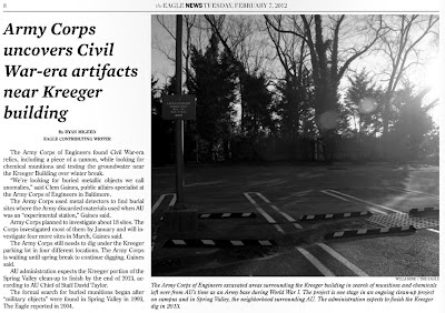 We’re looking for buried metallic objects we call anomalies,” said Clem Gaines, public affairs specialist at the Army Corps of Engineers in Baltimore. The Army Corps used metal detectors to find burial sites where the Army discarded materials used when AU was an “experimental station,” Gaines said ... The Army Corps still needs to dig under the Kreeger parking lot in four different locations. The Army Corps is waiting until spring break to continue digging, Gaines said.
Ryan Migeed
We’re looking for buried metallic objects we call anomalies,” said Clem Gaines, public affairs specialist at the Army Corps of Engineers in Baltimore. The Army Corps used metal detectors to find burial sites where the Army discarded materials used when AU was an “experimental station,” Gaines said ... The Army Corps still needs to dig under the Kreeger parking lot in four different locations. The Army Corps is waiting until spring break to continue digging, Gaines said.
Ryan Migeed
The Eagle
February 7, 2012 (pg. 8)
 In January, field teams intrusively investigated 18 single-point anomalies in the American University (AU) Kreeger Hall area. No WWI-related items were recovered. All the anomalies were classified as cultural debris, such as scrap metal and construction debris. Trench digging within the 4 anomalous areas in the paved area near Kreeger Hall is tentatively scheduled for March 2012. Because this effort will require removal of small portions of the Kreeger Hall parking lot, the investigation is scheduled during AU’s Spring break to minimize potential disruptions to campus life.
Spring Valley FUDS Project Summary
In January, field teams intrusively investigated 18 single-point anomalies in the American University (AU) Kreeger Hall area. No WWI-related items were recovered. All the anomalies were classified as cultural debris, such as scrap metal and construction debris. Trench digging within the 4 anomalous areas in the paved area near Kreeger Hall is tentatively scheduled for March 2012. Because this effort will require removal of small portions of the Kreeger Hall parking lot, the investigation is scheduled during AU’s Spring break to minimize potential disruptions to campus life.
Spring Valley FUDS Project Summary
January 2012
 A late-February final approval is expected for plans to clear buried World War I-era poisonous waste from the property at 4825 Glenbrook Road. The recommended plan, which the U.S. Army Corps of Engineers released in December, calls for tearing down the Spring Valley home and digging up to 12 feet beneath it to remove any buried munitions and chemicals ... The Army Corps has spent more than $200 million on munitions cleanup in the Spring Valley neighborhood since 2003. During World War I, the Army used American University as a testing site, firing weapons into then-undeveloped woods around the campus. In 1918, 4825 Glenbrook Road was a dumpsite for chemical and explosive munitions and related debris; officials believe a pit was disturbed there when a home was built in 1992 ...
.jpg)
Kent Slowinski, an advisory neighborhood commissioner in the area and former member of the Restoration Advisory Board, has expressed concerns that the current plan doesn’t account for possible poisonous residue left beneath the adjacent property, 4835 Glenbrook Road. According to Slowinski, bulldozers ran over bottles of a blistering agent at the border of the properties when the two houses were first constructed. In addition, he said, contractors planting a tree at 4835 Glenbrook in 1996 suffered from chemical burns when they sliced through a bucket of chemical-filled bottles.
Northwest Current
January 25, 2012 (pg. 2)
The Spring Valley partners and the Restoration Advisory Board have failed to act on many of these critical issues, which could cause the cleanup to drag on even longer. My main concern with the Army Corps’ “proposed plan” for 4825 Glenbrook Road is that there is no contingency for cleaning up adjacent properties ...
The Spring Valley partners failed to follow through on various commitments. For example, in 2001 the partners agreed to conduct indoor air monitoring at 4825 Glenbrook Road and five other properties to determine what chemical vapors were migrating from the soil into the house [pg. 2 of 6/24/02 Partnering Mtg. minutes] ... Eleven years later, this still has not been conducted at 4825 Glenbrook Road. Advisory neighborhood commissioners do not need advanced technical expertise to make informed decisions on these issues. There are many experts who can explain the issues in ways that anyone can understand. Examples include the Restoration Advisory Board’s technical expert, Dr. Peter deFurr, who compiled a list of the chemicals detected at 4825 Glenbrook Road; American University’s public health consultant, Dr. Paul Chrostowski, who asked the Army Corps to clean up the Glenbrook Road site to a stricter standard given the number of toxic chemicals detected on the site; and the Environmental Protection Agency’s Terry Slonecker, who identified the possible burial pit locations on the university campus.
Advisory Neighborhood Commission 3D needs to practice due diligence to make sure that a thorough investigation and cleanup of the Glenbrook Road properties is conducted. We need more oversight, not less.
Kent Slowinski, ANC-3D
Northwest Current Viewpoint
January 11, 2012 (pg. 9)
 Figure 10: Intersection of six circles denotes location of 1918 pit
UPDATED RANKINGS OF POSSIBLE SITES: Findings from the previous report, Terrestrial Photogrammetry of a 1918 Ground Photograph: Analysis of Three Potential 1918 Disposal Sites, Lockheed Martin, Las Vegas, NV August 2000, indicated that Site 2 was the most likely location of the burial pit, and sites 1 and 3 were ranked the next likely sites, in that order of likelihood. Site 3 was placed last because the resolution in a 1918 aerial photomosaic provided was so poor that the outline of buildings could not be discerned, providing insufficient evidence to support a higher ranking.
 Sgt. Maurer pit likely south of Army trailers above
In the process of determining the new coordinates for the three possible sites, a geographically-corrected map of the 1918 building locations and a much higher-resolution version of the photomosaic were acquired which showed the area in the vicinity of the burial site very clearly ... Figure 10 depicts the intersection of six circles that denotes location of 1918 pit for possible site 3 ... Coordinates of the site 3 1918 pit are: 773,328.3 feet in x; 401,185.8 feet in y (Maryland State Plane Coordinate System, NAD 1927).
E. T. Slonecker
Coordinate Computation of Ordnance Burial Site
December 2000 (pgs. 4 & 6)
 Likely location of pit is to the left (south) of trailers
 Anomaly next to Child Development Ctr. playground
This month the US Army Corps of Engineers (USACE) began preparations for the American University Kreeger Hall area anomaly investigation that is scheduled for January 2012. The Anomaly Review Board (ARB), which consists of USACE and the regulatory partners, identified 18 anomalies and four anomalous areas to be investigated. USACE worked with AU to schedule the anomaly investigations during AU’s winter break to minimize potential disruptions to campus life.
Spring Valley Project Update
December 2011
 Anomalies between Kreeger, Watkins & Hamilton Bldgs.
USACE requested feedback from AU regarding potential geophysical surveys and subsequent intrusive investigation in front of Kreeger Hall on the AU campus for the purpose of investigating a 1918 ground scar. This ground scar may be a shadow on the 1918 aerial photograph and received little attention early during the Spring Valley project, but someone from EPA subsequently described this ground scar as a probable 'T' [trench]. This ground scar is also located adjacent to elevated perchlorate detections at PZ-4.
 Anomalous area under road 80 ft. west of Watkins Building
 Free Hit Counter
 The exact location of the Maurer pit, as it is known, has remained a question. The corps believes, based on the photograph and other evidence, that a home next to the ambassador’s was built atop the pit, which may have been disturbed or even removed during construction ... Still, doubters remain. Kent Slowinski, a landscaper who grew up in the neighborhood and remains one of the corps’ most outspoken critics, believes the pit is higher on the hillside. “We keep finding out one thing after another where the Army corps says one thing and it turns out not to be true, and the situation turns out to be much worse than what they told us,” he said.


